
300 dpi: (d2591-1.jpg)
640 pixels wide: (d2591-1.jpg)
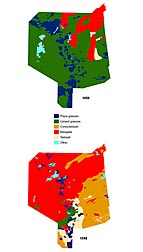 Image Number D2591-1 |
Maps of the Jornada Experimental Range show that grasses covered more than 80 percent of the land in 1858 (top) but covered only about 15 percent by 1998 (bottom). Mesquite, creosotebush, and tarbush displaced the grasses.
Photo courtesy of USDA-ARS Jornada Experimental Range.