
This page has been archived and is being provided for reference purposes only. The page is no longer being updated, and therefore, links on the page may be invalid.
|
Read the magazine story to find out more. |
|
|
|
|
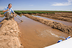
Aerial Imagery System Helps Save Water
By Dennis O'BrienSeptember 14, 2009
Agricultural Research Service (ARS) scientists are developing a system that saves water by using aerial imagery and ground-based sensors to determine the irrigation needs of small sections of cultivated fields.
Conventional irrigation practices, even when based on modern management and water application techniques, can be wasteful because they assume crop water needs are the same throughout an entire field, according to Douglas Hunsaker, an agricultural engineer at the ARS Arid-Land Agricultural Research Center in Maricopa, Ariz. It also is extremely difficult to go into a large field and visually observe and quantify different water needs for specific areas.
Farmers are beginning to use remote sensing technology to monitor crop growth, fertilizer needs and field conditions. Hunsaker's goal is to combine one remote sensing aerial image of a field with a system of wireless sensors tied to computer software that will accurately determine the irrigation needs of small areas on a daily basis throughout the season.
Ideally, farmers could identify areas with high or low water needs with data transmitted to their computers and, using either a drip or a sprinkler system, adjust irrigation levels based on the data. The technology could be particularly useful in the parched Southwestern United States, where conserving water is a major priority.
In a recent study, published in Agricultural Water Management, Hunsaker collected remote sensing images from aerial surveys of a 4-acre cotton field divided into 40 plots. The imagery tracked plant growth and water needs by capturing reflected light from the field in red and near infrared wavelengths; the bigger the cotton plants, the more infrared light captured in the images. Hunsaker used a computer program to analyze the imagery, determine optimal locations for supplemental ground-based sensors, and predict the variability of crop water needs throughout the field.
By conducting periodic aerial surveys throughout two growing seasons, he found that the system could accurately predict the diversity of crop water needs throughout the field. He is currently evaluating the use of ground-based sensors that would reduce costs by eliminating the need for all but one aerial survey each season.
Read more about this research in the September 2009 issue of Agricultural Research magazine.
ARS is the principal intramural scientific research agency of the U.S. Department of Agriculture.