| Channel Erosion on the Missouri River, Montana Between Fort Peck Dam and the North Dakota Border |

|
|
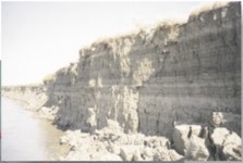
In July of 1994, Paul Johnson, who was Chief of the Natural Resources Conservation Service at that time, met with Dick Gooby, Montana State Conservationist, and the Lower Fort Peck Missouri River Development group in Wolf Point, Montana. Since 1994, the group has formed a Coordinated Resource Management Group, now known as the Lower Missouri River CRM. The group asked for help in solving problems involving erosion of the Missouri River bed and banks. In particular, the CRM group is concerned with the loss of agricultural land due to bank erosion and sedimentation around irrigation-pump sites. The Chief told the group that while the Corps has jurisdiction over the project, the NRCS would look into the erosion problem. At this time the Chief stated that erosion control and protection of natural resources are included in the mission of our agency, and that the NRCS would take the lead in coordinating an interagency study of erosion process. This project was formed and supported by the NRCS because it is a project with national significance. For example, the Missouri River was placed on the list of North Americas ten most endangered rivers by the environmental group American Rivers in April 1997. In July 1998, the group launched a five-year "Voyage of Recovery" for a "healthier and more beautiful Missouri River" that was covered by the Great Falls Tribune on July 7, 1998. Download The Entire Report Here |