
| Engineering Evaluation of Channel Stability on the Upper Missouri River, Montana |

|
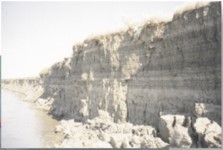 |
In-situ shear-strength determinations of 10 of the principle soil series along this reach of river provided effective cohesion and friction-angle data by which to assess bank stability conditions under a variety of soil moisture and tension/desiccation cracking conditions. For all units in all soil series, mean effective cohesion and friction angle are 16.6 kPa and 24.9?, respectively. Effective cohesive strength ranged from 0.0 kPa in sands and desiccated clays to 45.3 kPa in moist clays. Matric suction was found to contribute as much as 100% of the apparent cohesion. Bank-stability charts were developed from shear-strength and bank profile data to estimate stable-bank configurations. Vertical face bank angles would need to be reduced to about 30-40? to reduce failure frequency. Toe erosion of failed blocks and cracking of soils from tension, desiccation, and probably internal pressure from introduced water and probably ice in winter months, were identified as major contributors to bank-stability problems.
To evaluate bank-stability conditions and channel migration before and after the closure of Ft. Peck dam, analysis of field data and of historical maps and aerial photographs are used. Ice effects are also to be analyzed in terms of bank erosion from direct impact, rafting, interstitial expansion and freeze-thaw, and erosive effects of flowing water beneath the ice cover.
Point of Contact:
Dr. Andrew Simon, Retired