
ARS Home
» Northeast Area
» Beltsville, Maryland (BARC)
» Beltsville Agricultural Research Center
» Hydrology and Remote Sensing Laboratory
» Docs
» Crop Condition and Yield Research
» pro01fig8
| pro01fig8 |

|
Locations in Mclean County
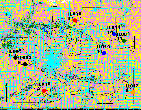
Purple - Soybeans
Yellow - Corn
Cyan - Road network from EROS Data Center
Dark Green - Forest/Trees
The IL# is the soil type, the number below that is the select# for the listing below.
Locations below are approximate. The 2 x 2 mile areas do not always incorporate the point locations. However, the sample area should be within 1 mile of the point. Once exact locations have been designated the locations will be updated. Currently there are 8 sites, but these will be reduced to 6 depending on farmer participation
Approximate locations of study areas:
| Soil type | select # | Lat | Long |
|---|---|---|---|
| IL003 | 1 | 40.50000 | -89.21861 |
| IL003 | 9 | 40.46861 | -89.15611 |
| IL010 | 4 | 40.34361 | -89.03111 |
| IL010 | 11 | 40.68750 | -88.84389 |
| IL014 | 11 | 40.53139 | -88.65639 |
| IL014 | 14 | 40.62500 | -88.59389 |
| IL081 | 17 | 40.59389 | -88.53139 |
| IL012 | 6 | 40.34361 | -88.46861 |