This page has been archived and is being provided for reference purposes only. The page is no longer being updated, and therefore, links on the page may be invalid.
| Read the magazine story to find out more. |
|
|
|
|
Soil Erosion Modeling: It's Getting Better All the Time
By Ann PerryApril 23 2012
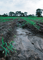
About 50 years ago, scientists at the U.S. Department of Agriculture (USDA) devised the Universal Soil Loss Equation (USLE), a formula farmers could use to estimate losses from soil erosion. Agricultural Research Service (ARS) scientists will soon release a version that integrates models generated by cutting-edge computer technology, an updated soils database, and new findings about erosion processes.
ARS is USDA's chief intramural scientific research agency, and this work supports the USDA priority of promoting international food security.
The original USLE used five factors to estimate the tons of soil lost per acre per year from the impact of raindrops and the flow of runoff water across fields disturbed by plowing and tilling. The formula is now used as the basis for estimating soil erosion wherever land is disturbed by farming or other human activities.
Every conservation plan written by the USDA Natural Resources Conservation Service has been based on soil-erosion calculations derived from USLE or its successors, the Revised Universal Soil Loss Equation (RUSLE) and version 2 (RUSLE2). Now research leader Seth Dabney, who works at the ARS Watershed Physical Processes Research Unit in Oxford, Miss., is putting the finishing touches on an update of RUSLE2, which uses more intricate combinations of observation- and process-based science to produce soil erosion estimates.
New formulas have been added that can generate simulations of pasture plant lifecycles, which in turn can be used to estimate the effects livestock and their different grazing patterns will have on soil erosion. The revised equations can also produce estimates of how much plant residue can be removed from crop and pasture lands for ethanol production without exposing the soil to excessive erosion.
RUSLE2's revised database contains information for the entire United States on climate and soil properties that affect erosion. The database also includes detailed descriptions of management systems that are organized in 75 crop management zones nationally. RUSLE2 can now also be used to predict runoff amounts and to develop a representative runoff event sequence that can be linked with a process-based channel erosion model.
More information about RUSLE2 can be found at /Research/docs.htm?docid=5971.
Read more about this research in the April 2012 issue of Agricultural Research magazine.


