This page has been archived and is being provided for reference purposes only. The page is no longer being updated, and therefore, links on the page may be invalid.
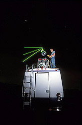
Read the magazine story to find out more. | LiDAR: A Bright New Trend in Environmental StudiesBy Luis PonsOctober 18, 2004 The atmosphere--and especially the air around agricultural operations--is being studied in a whole new light with technology adapted by Agricultural Research Service scientists and their cooperators. Researchers at the ARS National Soil Tilth Laboratory in Ames, Iowa, in collaboration with the University of Iowa, are examining many of the environmental and agricultural applications of the technology called LiDAR. According to ARS laboratory director Jerry Hatfield, the technology may revolutionize how the air around agricultural operations is monitored because it can pinpoint the location, distribution and nature of airborne particles. A product of 1960s laser studies, LiDAR--for Light Detection and Ranging--is a radarlike technology that uses short pulses of laser light to detect and differentiate airborne particles, gases or molecules. Its tight, unbroken beam disperses very little as it moves away from its source. LiDAR has been used to look at clouds and pollution plumes, hunt submarines, nab speeders and prepare topographic elements for land and ocean-floor maps. Hatfield and ARS soil scientist John Prueger--and, at times, UI professor Bill Eichinger--have used LiDAR to monitor the accuracy of remote sensors, water uptake by trees near rivers, and dust particles from mills, cotton gins and even odorous livestock facilities. The team first used LiDAR in 1998, when asked by the U.S. Department of the Interior to study the effect of saltcedar, an invasive and prolific shrub that extracts large amounts of soil water while leaving behind soil-damaging salts, on western U.S. riverbanks. More recently, they've used it in a series of soil moisture experiments, called SMEX, in which ARS, the National Aeronautics and Space Administration, the National Oceanic and Atmospheric Administration and numerous universities are evaluating how accurately remote sensors on satellites, aircraft and land-based towers monitor ground-level moisture. Hatfield, through an agreement with UI, is currently studying LiDAR's performance in evaluating dispersion dynamics around swine-production facilities. Read more about this research in the October 2004 issue of Agricultural Research magazine. ARS is the U.S. Department of Agriculture's chief scientific research agency. |