
This page has been archived and is being provided for reference purposes only. The page is no longer being updated, and therefore, links on the page may be invalid.
| Read the magazine story to find out more. |
|
|
Patented Method Transforms Digital Cameras for Aerial Color Infrared Photography
By Don ComisSeptember 22, 2011
The U.S. Department of Agriculture (USDA) and David Linden, a technical consultant currently serving as a chief scientist at Science Applications International Corporation (SAIC) in McLean, Va., have jointly patented technology that transforms commercial digital cameras to color infrared cameras for aerial photography.
Raymond Hunt, a physical scientist at the Agricultural Research Service (ARS) Hydrology and Remote Sensing Laboratory in Beltsville, Md., and Linden did this by choosing a 12-megapixel camera sold without an internal filter that blocks near-infrared (NIR) light. They then added a custom-made lens filter to block red light and transmit NIR. ARS is USDA's principal intramural scientific research agency.
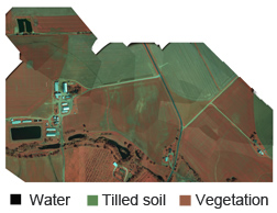
The patented method allows photographing with light in the NIR, green and blue bands, which are used to measure the "greenness" of vegetation and extent of crop canopy cover. There is no need for further processing, so the images are available immediately upon landing. The cameras are also lighter and more compact than the traditional larger format cameras used for aerial infrared photography.
Hunt and Dean Hively, a U.S. Geological Survey scientist stationed at Beltsville, have found the photographs useful for detecting the extent of farmland in the Chesapeake Bay Watershed that is protected from soil erosion by winter wheat and other winter cover crops.
Hunt and Hively are seeking to increase the spatial resolution to identify plant species and to measure the amount of chlorophyll in a single leaf of a crop. The scientists use their cameras aboard both airplanes and small Unmanned Aerial Vehicles (UAVs). UAVs can fly as low as a few hundred feet. Currently, UAVs cannot be flown for commercial use. The U.S. Federal Aviation Administration is developing rules and regulations on UAVs for safe applications.
Chlorophyll in leaves may indicate the amount of nutrients in the soil, so aerial imagery may be a way to help farmers save money by applying fertilizers more efficiently, which also helps protect the Chesapeake Bay.
Read more about this research in the September 2011 issue of Agricultural Research magazine.
Hunt, Hively, Linden, and colleagues have published papers on this research in the Agronomy Journal and Remote Sensing.