
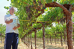
 ARS hydrologist Bill Kustas measures grapevine canopy width at a California vineyard to help evaluate satellite data used in models of vine water use. Click the image for more information about it.
Bringing Space Technology to Water Needs in California Vineyards
December 13, 2017
ARS scientists are saving water in California's vineyards by using satellite data and computer models to better manage water resources.
Bill Kustas and Martha Anderson are fine-tuning computer models at the ARS Hydrology and Remote Sensing Laboratory in Beltsville, Maryland, to help vineyard managers determine how much water to apply and when to apply it. The models tap into satellite data that measure land surface temperature providing information about soil and vine moisture levels and rates of water use or "evapotranspiration."
Winemakers want grapes of uniform quality, and that can be a challenge with vineyards that have different soils and climatic conditions across thousands of acres. Even a single vineyard can have a variety of irrigation needs, according to Kustas, an ARS hydrologist.
The ARS model uses satellite measurements of land surface temperature in a unique way by separating out the vine canopy from the soil surface temperatures. This gives the model greater precision and enables researchers to better evaluate vine stress, says Kustas.
Known as precision agriculture, the approach is helping the E. & J. Gallo Winery cut water use by allowing the grower to identify specific vineyard areas that are under stress and need irrigation. Gallo owns and operates 25,000 acres of vineyards in California and contracts with grape producers operating another 200,000 acres. The results also will be shared with other vineyard operators, offering the potential to save water across more than a million acres of vineyards in California.
With water supplies critical in California, the state's nut and fruit orchard operators are also likely to benefit from these efforts, Kustas says.
Over the next two years, the ARS researchers plan to develop a daily digital map of evapotranspiration in California's Central Valley, which includes some of the world's most productive agricultural lands, at a resolution that will give growers a firm grasp of conditions in specific areas within their fields.
You can read more about this research in the December 2017 issue of AgResearch magazine.
For more information contact Dennis O'Brien, ARS Office of Communications.
The Agricultural Research Service is the U.S. Department of Agriculture's chief scientific in-house research agency. Daily, ARS focuses on solutions to agricultural problems affecting America. Each dollar invested in agricultural research results in $20 of economic impact.