CEAP Choptank River Watershed ProjectThe Choptank River Watershed Project is part of a larger network of watersheds across the nation called the Conservation Effectiveness Assessment Project (http://www.nrcs.usda.gov/TECHNICAL/NRI/ceap/). The primary focus of this work is to evaluate how well USDA conservation practices are working on a watershed scale to protect or improve water quality. This project began in 2004, and it includes a number of USDA-ARS scientists, and partners from multiple federal and state agencies, universities, county extension, soil conservation districts, and local producers.  The Choptank River is a tributary of the Chesapeake Bay, and much of its watershed is used for agricultural production. Water quality data has been collected in the Choptank River over the last 25 years and other long term data collections make this watershed especially useful for this work. Innovative new technologies are being used to examine conservation practices on the landscape like cover crops, riparian buffers, restored wetlands, and controlled drainage systems. Results are regularly reported to customers and stakeholders through various events in the region. Some recent accomplishments in this project are: The Choptank River is a tributary of the Chesapeake Bay, and much of its watershed is used for agricultural production. Water quality data has been collected in the Choptank River over the last 25 years and other long term data collections make this watershed especially useful for this work. Innovative new technologies are being used to examine conservation practices on the landscape like cover crops, riparian buffers, restored wetlands, and controlled drainage systems. Results are regularly reported to customers and stakeholders through various events in the region. Some recent accomplishments in this project are:
- Improving Cover Crops. Remote sensing technologies were combined with agronomic practice data to determine biomass and nutrient uptake by winter cover crops. Critical factors governing uptake were planting date, crop species, and planting method. A threshold cover crop biomass of about 1 ton per acre was observed to control root zone nitrate. Results of this work have been used to improve the effectiveness of the Maryland Cover Crop Program, and improved nutrient efficiency values have been developed with the Chesapeake Program Office Nutrient subcommittee for use in the Chesapeake Bay water quality model.
- Forested Wetland Function Revealed. A combination of RADAR and LiDAR remotely sensed data was used to develop fine resolution maps of forested wetlands within the Choptank Watershed and to monitor their hydrology (i.e., inundation and soil moisture). This work provides a powerful new approach to examine wetland connectivity and to monitor wetland function on a landscape scale. These tools will also be critical in determining the regulatory status of wetlands under the Federal Clean Water Act, and they can be used to assess ecological services provided by wetlands. For example, information gained on the biogeochemical status and landscape connection of wetlands provides an important indication of the role of wetlands in retention or removal of agricultural nutrients or pesticides from agricultural production areas. Furthermore, these tools can be used to monitor the effectiveness of broad scale wetland hydrologic restoration.
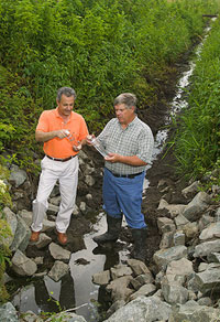 Controlled Drainage for Nutrient Reduction. Drainage ditches are extensively used in the Choptank and provide a rapid pathway for nutrients to move into streams. Studies have shown that an average of 6% of nitrate applied to agricultural fields can be transported in drainage water to receiving surface waters. Water control structures installed at the drainage outlet were evaluated as a potential conservation practice. Proper management of these structures not only reduces water flow, but also nutrients, mainly N, due to enhanced denitrification. Drainage control structures are often managed to increase water levels to just below the root zone during the growing season and to near the bottom of the drainage ditch during planting and harvesting. Proper management of these structures can potentially reduce nitrate losses in drainage water from 15% to 30%. These results have led to the addition of controlled drainage to the Maryland cost share program. Controlled Drainage for Nutrient Reduction. Drainage ditches are extensively used in the Choptank and provide a rapid pathway for nutrients to move into streams. Studies have shown that an average of 6% of nitrate applied to agricultural fields can be transported in drainage water to receiving surface waters. Water control structures installed at the drainage outlet were evaluated as a potential conservation practice. Proper management of these structures not only reduces water flow, but also nutrients, mainly N, due to enhanced denitrification. Drainage control structures are often managed to increase water levels to just below the root zone during the growing season and to near the bottom of the drainage ditch during planting and harvesting. Proper management of these structures can potentially reduce nitrate losses in drainage water from 15% to 30%. These results have led to the addition of controlled drainage to the Maryland cost share program.
- Modeling the Future of the Choptank. Better management of land use in Bay area watersheds requires improved understanding of the linkage between land use and water quality. Our project adjusts water quality models to represent landscape conditions on the Eastern Shore which will better enable identification of environmentally critical areas within watersheds and targeting of conservation practices.
- Customer Outreach. Our project recently conducted a customer workshop within the watershed to prioritize future research efforts. The highly positive feedback from this workshop has established the value of receiving regular customer and stakeholder input in establishing relevant research outcomes.
- Contacts
Greg McCarty, Greg.McCarty@ars.usda.gov, 301-504-7401
Laura McConnell, Laura.McConnell@ars.usda.gov, 301-504-6298
|


