The Salt of the Earth
Researchers use remote sensing and precision technology to aid growers in arid regions
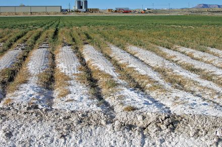
One of the main challenges of irrigating crops is that available water sources contain salt. Over time, repeated waterings from these sources lead to salt accumulation, damaging soil fertility. This issue is especially acute in the arid and semi-arid regions found in much of the western United States. To address the issue, researchers are beginning to apply the techniques of digital and precision agriculture to help growers provide their crops with the water they need without harming them, or the soil, in the process.
Their efforts combine a variety of strategies and tools. Todd Skaggs, research leader at ARS’s Agricultural Water Efficiency and Salinity (AWES) Research Unit, in Riverside, CA, described several ideas that his team is exploring. One approach is to develop crops with a higher salt tolerance, including working to understand that trait at a genetic level. Recently, the AWES team has focused on alfalfa, using greenhouses to grow a variety that is significantly more salt-tolerant than conventional varieties.
The researchers have also leveraged remote sensing data from satellites to inform their picture of salinity levels in fields. While satellites cannot directly detect the presence of salt within the root zone, they can measure several factors that reveal it indirectly. For instance, because soil salinity levels tend to be steady over time, multi-year measurements of plants can provide a “salinity signal” about the condition of the soil that is distinct from other, more transient phenomena affecting plant growth. In the future, researchers hope to collaborate with university partners to create an app that producers could use to guide decision-making for irrigation and salinity management, improve water-use efficiency, and spot potential problems in fields where salts are accumulating. Ultimately, they also hope the crop industry will adopt and help share the tools they develop.
 Salt-affected agricultural soil in Grand Valley, Colorado near Fruita. (Photo courtesy of Don Suarez, USDA-ARS)
For now, though, “it’s more a demonstration of concept,” said Skaggs. His team has collected data and is performing ongoing analysis to fine-tune the accuracy of the models they have developed to measure and assess the level of salinity, based on irrigation patterns. In time, they believe these models will provide growers with substantially better information than they have now to inform how they farm.
“Where there are concerns about salinity, growers probably have, through extension, a general number they want to hit for how much irrigation water they have to apply,” said Skaggs. “But there’s really not much feedback available to a grower as to whether or not that’s too much, not enough, and so the ambition for what we’re doing is to develop some technologies and tools that would allow them to better understand when they irrigate, is it efficient, and could you be more efficient by maybe managing a little differently?”
It is a critical question for researchers and growers alike as they seek better ways to make use of the water that is, especially in the west, a precious, and increasingly scarce, resource. – By Kathryn Markham, ARS’s Office of Communications

