300 dpi: (d1841-1.jpg)
640 pixels wide: (d1841-1.jpg)
 Image Number D1841-1 |
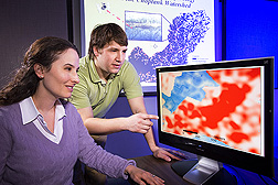
Megan Lang and University of Maryland graduate student Robert Oesterling compare forested wetland maps for relationships between low (blue) and higher (white) elevations on one map and wet (red) and drier (white) spots on the other map. The maps were created with two remote-sensing technologies, one using laser light (LiDAR, or light detection and ranging), the other radio waves (SAR, or synthetic aperture radar).
Photo by Peggy Greb.
