300 dpi: (d1113-1.jpg)
640 pixels wide: (d1113-1.jpg)
 Image Number D1113-1 |
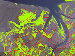
Color infrared aerial photograph of a portion of Willapa Bay (in Washington State) showing vegetation layer (green) areas. Oyster aquaculture areas are outlined in red. In combination with additional layers showing burrowing shrimp distribution, maps such as this can show the effects of aquaculture and pest-control strategies at the estuarine landscape scale.
Photo by Brett Dumbauld.
