

Dust in the Wind: Finding Solutions for Rangeland Erosion
 |
Nick Webb is a research physical scientist at the Range Management Research Unit in Las Cruces, NM. His research focuses on wind erosion processes in rangeland agroecosystems and development of management tools. |
Welcome to Under the Microscope, Dr. Webb.
UM: What problems does wind erosion pose for U.S. agriculture?
NW: Wind erosion is of great concern, because it reduces production, both directly and indirectly. It selectively removes fine soil particles, soil carbon, and nutrients, which negatively impacts soil health and land potential to produce crops and forage for livestock, and counters efforts to mitigate climate change by sequestering carbon.
Dust produced by wind erosion is also a major issue for water resources in the Upper Colorado River Basin. Dust falling on snowpack in the Rocky Mountains makes the snow darken and melt faster, changing the timing and availability of water for irrigation. Wind erosion can be accelerated by the spread of invasive plants that result in more bare ground on rangelands, and the spread of some species like honey mesquite (Prosopis glandulosa) is actually tied to wind erosion, with erosion processes promoting loss of perennial grasses and shrub dominance. Wind erosion also impacts community health across the U.S. by degrading visibility and air quality, which affect road safety and people with respiratory conditions, and is linked to Valley fever infections.
UM: What do we know about the causes of wind erosion?
NW: In spring, wind erosion is often driven by strong winds associated with cold fronts, while in summer strong winds that can erode soils may be associated with thunderstorms – like the haboobs around Phoenix. It can be accelerated by any land uses that increase the exposure of soils to strong winds or disturb soils so as to break apart protective crusts and aggregates. On cropland, wind erosion has historically been exacerbated by management systems that leave fields fallow during windy months of the year, and soils loose and dry. On rangeland, livestock grazing that reduces ground cover below critical levels (typically around 30%) and disturbs soils can accelerate wind erosion. By disturbing plants and soils, other land uses such as off-highway vehicle use and renewable and non-renewable energy production can also increase wind erosion and blowing dust.
UM: Has wind erosion always been a problem, or is it more severe now? Do we have approaches to managing it that have helped in the past?
NW: Research has shown there was a 500% increase in dust deposition, indicative of accelerated wind erosion, following western settlement of the U.S. during the nineteenth century. In the twentieth century, wind erosion was most severe in the U.S. during the 1930s Dust Bowl. Today, the area impacted by the Dust Bowl remains susceptible to wind erosion, although adoption of soil conservation practices has been effective in reducing wind erosion risk. The Conservation Reserve Program has also ensured that some of the most susceptible soils are protected.
Nationwide, we still have an incomplete picture of what’s going on. Recent studies have suggested that wind erosion in the western U.S. has increased over the last few decades. We are currently exploring how drought, vegetation change (e.g., shrub encroachment, spread of exotic annual grasses), and changing wildfire patterns are influencing the susceptibility of western rangelands to wind erosion. Avoiding vegetation- and soil-disturbing activities, reducing invasive plants, and adopting flexible (adaptive) stocking strategies with conservative forage utilization, have been and remain the most effective practices for reducing wind erosion on rangelands.
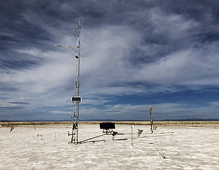 National Wind Erosion Research Network site on the Lordsburg playa, NM established to monitor dust emissions along Interstate 10 where blowing dust impacts visibility and driver safety. (Photo by Nick Webb, ARS)
UM: Does climate change influence erosion, and if so, how?
NW: Because wind erosion is controlled by interactions between plants, soils, and the atmosphere, and external factors like land use and management, these interactions can be complex and difficult to predict. Generally, if we see increased windiness and/or reduced vegetation and drier soils, or if climate change promotes invasive plants or change in wildfire behavior, then rates of wind erosion could increase. If climate change reduces the availability of irrigation water, then currently irrigated areas may become more susceptible to wind erosion.
UM: What do we know about solutions?
NW: Generally, maintaining vegetation cover and minimizing soil disturbance are part of solutions to reduce wind erosion. On cropland, using minimum- and no-till systems, retaining crop stubble and residue, and planting cover crops, buffer strips, and windbreaks can be helpful. On rangeland, the intensity, timing, and duration of livestock grazing can be managed to ensure that sufficient vegetation remains to stabilize soils. Managing wildfire and invasive plants is also an integral part of wind erosion management. We are working on approaches to assess how wind erosion responds to different uses and to provide managers with tools to evaluate land use options.
UM: How is ARS research tackling the problem?
NW: The ARS is conducting research on different aspects of wind erosion and tools to support its management. Here at the Range Management Research Unit, we collaborate with several organizations through the National Wind Erosion Research Network to develop wind erosion prediction and interpretive tools. These tools are developed with land managers in mind.
Our work includes projects looking at how invasive plants can exacerbate or reduce soil erosion, effects of wind erosion on carbon sequestration, and the impact of dust-on-snow on water resources and agriculture.
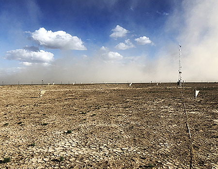 Sediment samplers collect data, which, coupled with standard transect-based methods, supports wind erosion model development and applications across grazing lands. Here, the samples are monitoring post-fire wind erosion in the Great Basin to calibrate the AERO model. (Photo by Nick Webb, ARS)
UM: How and why do we model erosion? Can we measure the cost of erosion?
NW: Erosion models provide a critical tool for land managers. Wind erosion rates have very large variability across space and through time, which generally makes physical monitoring difficult and cost-prohibitive. With erosion models, users can assess erosion risk with minimal inputs on soils, climate and land management or using data collected onsite using standard monitoring protocols. ARS developed the Wind Erosion Prediction System (WEPS) as a conservation planning tool for cropland. Recently, my team has developed a new model called the Aeolian EROsion (AERO) model for rangelands, which estimates sediment transport and dust emission rates (including PM10 and PM2.5 emissions) using standard monitoring data collected across U.S. rangeland and pasture land. We have also developed the Landscape Data Commons, which harmonizes and aggregates several monitoring datasets and models, and provides users with predictions that can be interpreted in the context of other land health indicators.
It is very difficult to measure the costs of wind erosion because they are so extensive. We are currently developing an estimate that includes the health impacts of blowing dust, costs to infrastructure, and onsite costs of erosion mitigation on cropland. Our conservative estimates suggest that the cost of wind erosion annually compares with other major natural hazards.
UM: How might an individual such as a rancher or other land manager use this information to combat erosion, in practice?
NW: Individuals can access AERO model predictions of wind erosion online through the Landscape Data Commons and through the USGS/BLM Land Treatment Exploration Tool. Model predictions are currently available for around 50,000 locations on public rangelands and we continue to add predictions. Interpreting model predictions can be difficult, so we are developing tools that managers can use to assess local wind erosion risk in an ecological and production context, and understand local risks in the context of regional patterns and trends. Our goal is to mainstream wind erosion information by improving the quality and availability of erosion prediction tools and ensuring that those tools, like AERO, fit within the knowledge systems that land managers use.
For more information on wind erosion tools and research, please visit the National Wind Erosion Research Network, a part of the USDA-ARS LTAR Network.