

Raindrops Keep Falling: Understanding and Managing Water Erosion
 |
Ron Bingner is an agricultural engineer and the research leader with the Watershed Physical Processes Research Unit, a component of the National Sedimentation Laboratory, located in Oxford, MS. His research focuses on predicting and controlling sediment yield and other pollutants, and investigating and evaluating systems and conservation practices for improving water quality. |
Welcome to Under the Microscope, Dr. Bingner.
UM: What is water erosion?
RB: Water erosion is the movement of soil from the surface of landscapes caused by the energy of water. Most of our landscape features, such as channels and valleys, are the result of long-term water erosion processes. Water erosion is an important problem, affecting our water quality and our ability to produce enough food to sustain the world.
UM: What problems does water erosion pose for U.S. agriculture?
RB: When major storms produce runoff that transports a lot of sediment without any deposition, or when humans disturb the landscape beyond what the natural balance of the system can maintain, then this poses a challenge.
Agricultural landscapes include forests, rangelands, and row crops. Forests can often absorb a lot of the energy from water, either from rainfall or snowmelt, but when trees are removed, the energy of water can begin to reach the soil surface and cause erosion. Rangeland systems often have an interconnected mix of cover and root systems that protect the soil from significant soil loss that require careful management of grazing operations. The challenge of managing sustainable croplands is that it requires balancing the amount of soil disturbance needed to grow crops economically with minimizing the impact on the environment. The natural renewal of soil on croplands is very slow and requires preventing too much eroded sediment from leaving the fields. Since soil often erodes very slowly, the impact of changing practices is often not apparent until many years later. Since soil is not easily renewable, we can think of it as a finite resource that requires careful management.
UM: How significant is the threat?
RB: If too much sediment moves downstream, habitats, stream systems, water resources, and drinking water can be affected, since sediments can sometimes carry harmful levels of chemicals and nutrients. When that happens, it requires measures to clean the water or dredge rivers and other water bodies of the harmful sediment and locate safe storage sites for it, which has both economic and environmental costs.
We see examples of problematic water erosion in many places, both here and abroad: Hypoxia in the Gulf of Mexico is a direct result of runoff and soil erosion in the Mississippi River Basin. There are other rivers around the world, including the Amazon and Yangtze, that are directly impacted by human activity (deforestation primarily) and resulting soil loss from adjoining lands. Overall, the severity of the threat varies in different geographic locations, but outcomes like hypoxia in the Gulf and elsewhere indicate that water erosion is a meaningful issue for agriculture and beyond.
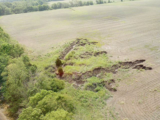 An aerial view of a section of James Creek, in Mississippi, where channel incision has led to rapid bank erosion causing land loss and high suspended sediment loads within the water. (Photo by Ron Bingner).
UM: Does the amount and kind of water erosion vary geographically, and if so, how?
RB: The geographic conditions where water erosion occurs can greatly affect the type and amount of sediment eroded. The main factors affecting water erosion are climate, soil, vegetation, and topography. The climatic regions and soil characteristics vary throughout the U.S., with physical properties that affect infiltration capacity and thus the amount of water available for erosion and transport of sediment. The erodibility of the soil is influenced by soil structure, texture, organic matter, moisture content, and density. Vegetation affects erosion by intercepting rainfall and absorbing the energy of raindrops before hitting the ground, and by slowing the flow of water that then reduces the capacity to carry sediment.
Differences in erosion can occur in watersheds when water flows from steeper slopes to flatter slopes where sediment may be deposited. When water flows from flat slopes to steeper slopes then water that is not carrying much sediment in the flat areas would tend to accelerate when approaching steeper slopes and produce more erosion and transport sediment farther.
UM: How does climate change influence water erosion?
RB: In some parts of the country, climate change may lead to changes in rainfall and increased rainfall intensity or duration that could both promote increased soil erosion. Increased temperatures can lead to an early and increased snowmelt that may erode and transport more sediment. Increased temperatures could also lead to soils drying out faster, which may reduce the potential for runoff and erosion. However, some soils can form a crust at the surface as they dry out, creating a barrier that reduces the amount of water that can soak into the ground, and leading to increased runoff.
UM: What do we know about solutions?
RB: We know that there are effective solutions to reduce erosion, such as growing cover crops, reduced tillage, filter strips, and buffers. For gully erosion, using grassed waterways or drop pipes can be effective. Installing in-stream grade control structures or check dams or reversing channelization by returning channels to their original slopes can control channel incision and erosion.
Adoption of erosion control solutions requires careful consideration and maintenance, using a holistic, systems approach to evaluate everything as water flows through the watershed. Otherwise, these practices could encourage flooded conditions, sediment moving from one place and depositing in downstream locations, or it could produce more erosion downstream.
UM: How is USDA tackling the problem?
RB: Agencies such as USDA-NRCS have technologies (such as the Revised Universal Soil Loss Equation, Version 2 and Water Erosion Prediction Project) that provide long-term soil erosion estimates for current and future land use scenarios. Land managers can simulate and evaluate various management and cropping systems to find the best conservation management plan, since one size does not fit all.
In general, we need a systems approach to examining erosion issues so we can understand questions like whether one management practice is influencing other processes. For example, adoption of conservation tillage for crop production may help mitigate sheet and rill erosion, but accelerate other forms of erosion. What we don’t know as much yet is if erosion is increasing in other areas, such as gullies, streams, or rivers, because of less sediment eroding within fields. In many areas of the country, the source where sediment originates is not well understood and requires more research.
UM: Is there any emerging technology that may play a role in how we tackle water erosion?
RB: Unmanned aerial systems, or drones, can provide multiple types of remotely-sensed information on large landscapes, from the topography of the land surface to surveys of plants and how they grow.
As Artificial Intelligence (AI) is more widely adopted in agricultural research, it will lead to benefits like faster analysis of data when identifying problem areas in a field that would require attention, such as applying precisely-placed practices integrated with other practices where they will perform best before erosion can occur.
UM: As a practical matter, how would farmers or other land managers apply data about water erosion in their day-to-day work?
RB: As erosion prediction technology advances and integrates with remotely sensed data and climatic information, farmers or other land managers can look farther into the future to assess the state of their fields and decide where they can optimize their time and resources to maximize their economic and environmental benefits while sustaining their farms for the next generation of farmers. By being able to know when storm rainfall events occur and their intensity, this would provide critical management information on deciding when farming operations can best be performed to minimize soil erosion.
Robert Wells contributed to the information contained in this interview. He is a a research hydraulic engineer with the Watershed Physical Processes Research Unit located in Oxford, MS.