Drought and Evapotranspiration Monitoring
Use of satellite-derived maps of evapotranspiration for identifying and monitoring drought impacts.

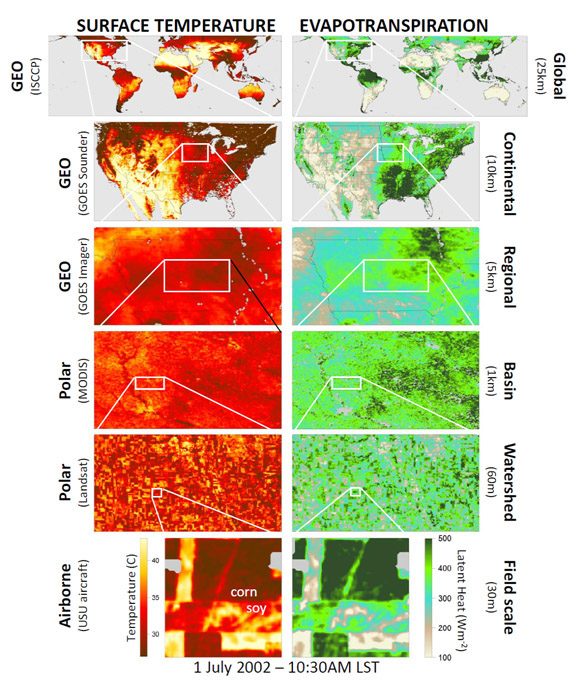
Multi‐scale ET maps using land‐surface temperature from satellites.
|
Recent Accomplishments:
-
Thermal-based model for monitoring ET is shown to be robust over natural and agricultural landscapes: The Atmospheric Land EXchange Inverse ALEXI daily flux estimates (10 km resolution) for 2000-present have been compared with observations from a number of Ameriflux sites across the U.S. in rainfed and irrigated crops, rangeland, natural vegetation, forests, and wetlands, yielding an average mapping accuracy of approximately 10% in comparison with observations. Further evaluation is ongoing in other regions, including Alaska, South America, North Africa, Europe and Asia. In addition, detailed investigations of downscaled daily fluxes (100 m) using data fusion and thermal sharpening techniques have been conducted using observations collected during the SMEX02 (Ames, IA) and BEAREX08 (Bushland, TX) field campaigns. Publication: Anderson, M. C., Kustas, W. P., Norman, J. M., Hain, C. R., Mecikalski, J. R., Schultz, L., Gonzalez-Dugo, M. P., Cammalleri, C., D’Urso, G. , Pimstein, A. and Gao, F. Mapping daily evapotranspiration at field to continental scales using geostationary and polar orbiting satellite imagery. Hydrol. Earth Syst. Sci., 15, 223–239, 2011.

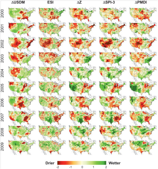
Seasonal (26 week) anomalies of several drought products USDM, ESI, Z, SPI-3, and PMDI for the period 2000–09. For more details go to the Evaporative Stress Index web site https://hrsl.arsusda.gov/drought/.
|
-
Improved thermal-based remote sensing tools for detecting the onset and modeling the evolution of drought: The Evaporative Stress Index (ESI) products (2000‐present) are being generated in real time over the Continental U.S. (CONUS) , with expansion to North America underway (see https://hrsl.arsusda.gov/drought/). ESI provided valuable early warning of flash drought events occurring over CONUS in 2012, relating to anomalous evaporative losses driven by an extreme heat wave settling over the Midwest. Additional modeling domains have been established over the Middle East and North Africa (MENA) countries in support of collaborations between NASA/USDA/World Bank and US‐AID. A global domain, integrating information from a suite of international geostationary satellites, is in development to support a Global Drought Early Warning System. Publication: Anderson, M.C., Hain, C. R., Wardlow, B., Pimstein, A., Mecikalski, J.R., and Kustas, W.P. Evaluation of a drought index based on thermal remote sensing of evapotranspiration over the continental U.S. J. Climate 24: 2025‐2044.
Contact:
Martha Anderson, martha.anderson@ars.usda.gov, 301-504-6616
|